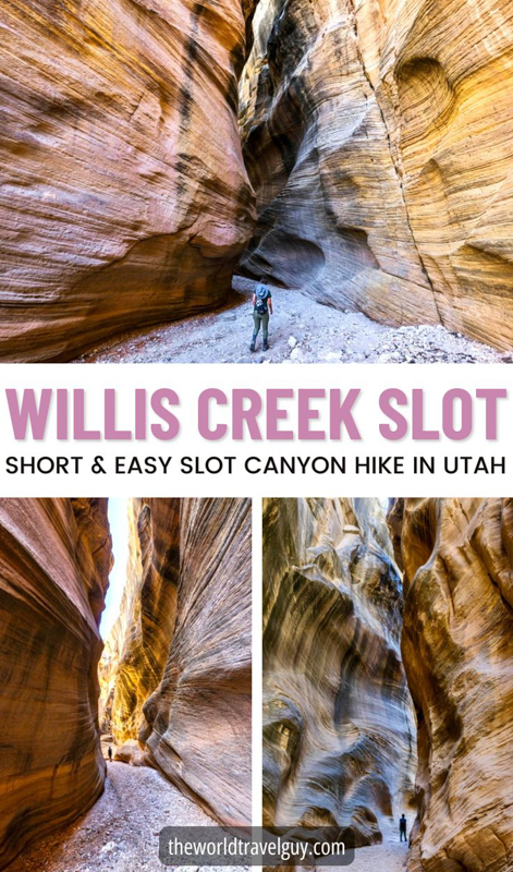
The Willis Creek Slot Canyon is a short and easy trail through some scenic narrows in southern Utah, with wavy vanilla-colored rocks and impressive passageways.
It’s a very family friendly hike, and the Willis Creek Canyon is located less than an hour from the popular Bryce and Escalante areas, so this is definitely a good one to add to your road trip through Utah!
This guide will explain how to get to the Willis Creek Narrows trail head, and everything else you need to know before you go!

Entering one of the best parts of Willis Creek Slot Canyon
Quick Stats
- Distance: 3+ miles (5+ km) round trip
- Elevation Loss: 175 feet (50 m)
- Duration: 1.5+ hours round trip
- Difficulty: Easy

Wavy rock walls
Willis Creek Slot Canyon: What To Expect
Some parts of the Willis Creek Trail are in a relatively open riverbed type canyon, while other parts are more like a true slot canyon, with dim lighting and steep, narrow walls.
The first shallow section of the Willis Creek Narrows starts after you walk only 250 feet from the trail head parking. Just cross the road from the parking area, follow the wash, and you’ll be inside the canyon before you know it!
The whole trail is straightforward and pretty much flat, so overall I’d rank it as one of the easiest and most family friendly slot canyon hikes we’ve ever done.


Near the 1/2 mile mark, there is an obstacle in the form of a tall drop off (pictured below), but you can easily go around it on either side to get back into the slot.
There’s also a shallow little stream of water that runs through the Willis Creek Narrows, but it’s usually small enough to hop over without getting wet, and when we went in September it had almost completely dried up.
We only saw a handful of people and a few horses on the trail when we visited on a weekday, so it doesn’t seem to be too busy yet, although there was some horse poop to avoid.

This steep pit is one of the only obstacles on the Willis Canyon trail, and it’s easy to pass on either side.

Even the wider sections of Willis Creek Canyon look pretty nice
The very best slot section we saw was near the 1 mile mark, where there’s a dark, steep passageway with wavy, vanilla-colored rock walls. Most of our pictures were taken in that slot and it was really impressive.
Most people will probably want to turn around at approximately 1.5 miles when the Willis Creek Trail splits into a T at Averett Canyon, because at this point you’ve already seen the best parts of the canyon.
You can turn right at this junction and continue going as far as you want (some people go the full 3+ miles to Sheep Creek), but the path widens and it doesn’t really look exceptional anymore.
I’ve read, but can’t confirm, that there are some neat petroglyphs on the wall near the 3 mile mark. Let us know in the comments if you find them!

Entering the Willis Creek Narrows
I’ve heard from some people who were disappointed by the Willis Creek Trail. We loved it because of the tall narrow rock walls, and because the hike is so easy. I think it’s plenty of ‘bang for your buck.’
It’s true that the rock colors are not as nice as some other slot canyons in Utah, and it can also be a bit hard to photograph this one because the walls are often not narrow enough to keep out the harsh sunlight.
The slot canyon sections don’t last particularly long either, but we still found the whole thing really enjoyable.


Map Of The Trail
Here’s a map from AllTrails that shows the hiking route.
Most of the map is accurate except for the elevation gain, which is off because of a mapping error. Don’t worry, this is a flat and easy hike.
We turned around after about 1.5 miles since that’s where the best narrows ended.
If you sign up for AllTrails Plus, you can download the map and use it offline while hiking. It’s very handy!
Trailhead Location For Willis Creek Canyon
The Willis Creek Canyon trailhead is located outside of Cannonville, Utah, which is near the Bryce and Escalante areas in southern Utah.
Here are the GPS coordinates: 37.48367148543457, -112.09733707849618
You can click on this link to open it in maps and navigate you directly to the parking lot, which is a 1 hour drive from either Bryce or Escalante.
The trailhead is right across the road from the car parking.
Trailhead Conditions
The last part of the drive to the Willis Creek trailhead involves 20 minutes on a bumpy back road (BLM500/Skutumpah).
It’s a very bumpy dirt washboard with several steep uphill sections that could be a problem for some vehicles, although we made it fine in 2WD.
There weren’t any big potholes, so I think you could do the drive in most vehicles as long as the road is dry, but don’t come here after rain!
The parking lot at the trailhead has some information signs, a basic map of the trail, and more than enough parking space, although there’s no bathroom.
This hike is part of the Grand Staircase-Escalante National Monument, which is managed by BLM. As always, please remember to keep the trail clean, be considerate of other hikers, and leave no trace. Thanks and happy travels!

The Willis Creek Trail starts across the road from this sign

Willis Creek Trailhead
Slot Canyon Safety Tips
Flash Floods. Always be aware of the weather forecast. Do not enter any slot canyon if rain is in the forecast, even if it's outside of your immediate area. Flash flooding can be very dangerous in a slot canyon.
Sunscreen. Even on a slot canyon hike, there are still plenty of parts on the trail where you'll be exposed to direct sun, so you might want sunscreen. A hat helps too.
Water. Try to pack at least 3-4 liters per person. In Utah, you should always bring more water than you think you need.
Map. It's a good idea to download an offline map of your hiking area on an app like Google Maps, that way you can keep using it to navigate or find your position even when you're out of reception. Getting lost in the desert can be dangerous.
Where To Stay In Escalante


More Things To See Nearby
Willis Creek Slot Canyon is not far from Bryce or Escalante in southern Utah, so there are lots of nearby attractions.
We did this hike while we were en route from Bryce to Escalante, which worked out great because it’s just a short detour off the main road between them.
You could also easily combine Willis Creek with a visit to Kodachrome Basin State Park, since they’re just 30 minutes apart.
Best Utah Tours
More Utah Slot Canyon Guides
Thanks for looking! I hope you enjoyed this guide for the Willis Creek slot canyon hike near Escalante, Utah.
Don’t forget to check out my complete Utah Slot Canyon Guide to see more good ones!